Tuesday, November 5, 2013

HSMM-MESH Valley Hub Sites Testing!

Email regarding HSMM-MESH from David Bauman, KF7MCF, sent on October 30, 2013


Two Sites in Test Mode!

SLCC (Salt Lake Community College Hub Site)


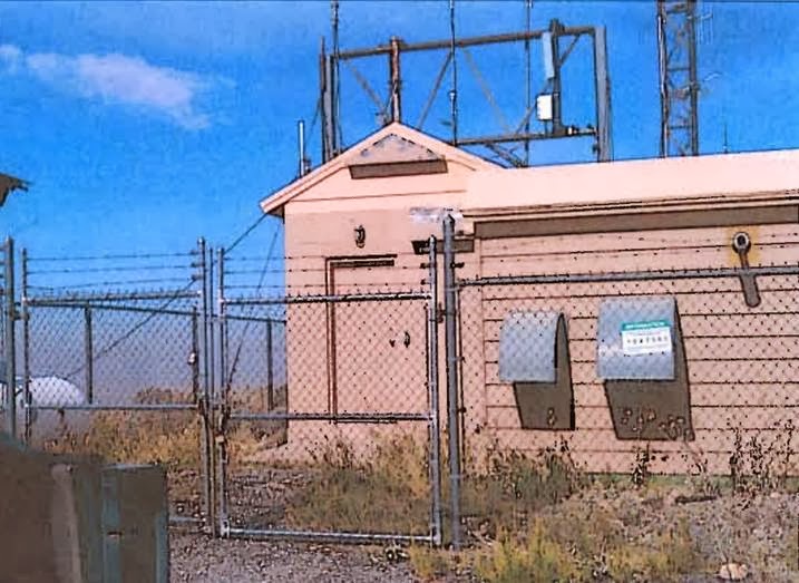
The above photos show the SLCC Valley Hub Site.  It is composed of a High Power 2.4 Ghz Ubiquiti Bullet attached to a 15 dbi Commercial Omni Antenna (spec sheets attached).  The funny looking thing I am pointing at is a plastic pop bottle that is temporarily protecting the POE unit from the elements.  (Grant has replaced that with a weather proof box.)

This site is on top of a four story building at the Salt Lake Community College Campus.  It is running as an access point with regular Wi-Fi on Channel One with over 20 watts ERP output. With a little luck, the right equipment (and clear Radio Line of Sight) you should see it within about 5 miles, and you may see it out as far as 10 miles with the right equipment, skills, and circumstances.


Below is a view shed or rough idea of where the signal will hit out to about 5 miles.  The bite out of the circle at the bottom is because of elevation difference - Might be a coverage area also with a good antenna and a good Ham.


Ensign Peak Hub Site Testing also!


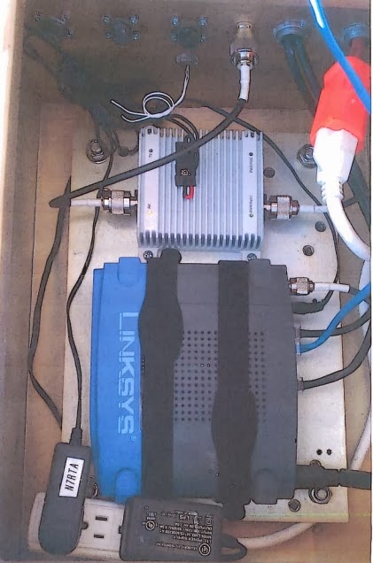
It is composed of a Linksys WRT54 router running HSMM-MESH 4.3 into a Renasis 1 watt Bi-directional Amplifier, and then Into a 17 dbi gain 90 degree Sector antenna with a bit of a down tilt (about 4-5  degrees)  


Below is a plot showing the Possible coverage area out to 10 miles.  If you are about half that distance, you have a good chance of connecting, with The right hardware, Clear Radio Line of Sight, and a bit of skill.  Remember, the signal does not hit the ground for about The first mile because of the elevation of Ensign Peak, and the 7.5 degree vertical beam out of the antenna.  This HSMM-MESH site is on Ch 1.  Because of the different operating Modes, the two Hub sites will not connect at the present.   Later that Will be resolved.  The Ensign Peak and SLCC sites are about 10 miles apart.  Credit for this site goes Ed Sim (N7RTA) and some of the guys from L3 group.  Nicely done!


The view below shows the possible combined coverage of Ensign and the SLCC Valley Hub Sites.  The other possible Future Valley Hub Sites shown  with distance from The SLCC Valley Hub are:  Church Headquarters (7 miles), Welfare Square (6 miles), Magna Bishop’s Storehouse (7 miles), and The Sandy Bishop’s Storehouse (6 miles), New IHC Med Center 2 miles, Storehouse Distribution Center 7 miles.
(About 10 miles From the SLCC  Hub Site to Ensign Peak.)


The View Shed picture below shows Possible future valley coverage from all proposed Valley Hub Sites


We are making progress, it is slow, but someday…

Thanks for all your help!  Anyone that can help us get other proposed sites up, or that just want to participate, just let us know.  Meetings are held Saturdays at 9 AM at the Magna Utah Bishop’s Storehouse ERC Com Center on 2nd floor. You are welcome to come and join with us, and have a donut!

David T. Bauman
KF7MCF
Magna Utah Bishop’s Storehouse ERC


NOTE FROM THE BLOGMASTER --
If you are involved in the SLC HSMM-MESH and can reach one or any of these node, please comment on this posting and detail equipment used, location, call sign and other pertinent information.


Sunday, October 20, 2013

Unlicensed Cheap Chinese Radios Can Cause Trouble

I found a really good posting from David Coursey, N5FDL's blog...here is a teaser...

"Got a call the other day from a local man who said he’d paid something in the $80 range to purchase a pair of radios from Amazon. “I bought them to use when I go out hunting,” he told me.
You may already see where this is headed. He’s purchased two “Cheap Chinese” talkies in hopes of using them for emergency backup and routine communications while hunting in the Sierras. He wanted to know if, perhaps, he needed a license and what would happen if he used them without a license.
“Do it often enough and we will find you,” I hold him. “After that, we will turn you in to the FCC. You can expect a letter from a Mrs. Smith and if you don’t comply, the fine is $10,000. You should probably send the radios back before they get you into trouble.”
I went on the explain that a license wasn't hard to get, but everyone who would use the radios would need one."

Check out the full article at the following link:


Thursday, October 3, 2013

Communication in Colorado Flooding Response


Past news from the ARRL on the Colorado ARES response:


Photo from businessinsider.com
More than five dozen Amateur Radio Emergency Service (ARES) volunteers have deployed in and around
flood-stricken counties of Colorado, providing critical communication for Red Cross shelters and state and local emergency operation centers. Recent heavy rains have caused veritable mountainside tsunamis that have caused rivers and streams to overflow their banks, ravaged roads and property and displaced an undetermined number of residents. At least three people are known to have died. ARRL Colorado Section Manager Jack Ciaccia, WM0G, says that with power cut off to affected communities and many cell telephone towers along the Big Thompson River toppled by the flooding, ham radio is providing medical and health-and-welfare traffic between evacuation centers and the EOCs.

"Every EOC is being staffed by ARES people," Ciaccia told ARRL. "Almost every evacuation center has an ARES communicator, doing either voice or packet communications between EOCs and shelters."

The isolated towns of Estes Park, Lyons, and Jamestown were or still are relying solely on ham radio for contact with the outside.  Jamestown has since been evacuated. "Everybody was huddled into the high school there," Ciaccia told ARRL. He was in contact with the mayor there and trying to get the community needed resources as soon as possible. Hams in Estes Park have been working out of the EOC in
the Town Hall, which is on high ground. "There's no place to go. Everything's flooded," Ciaccia said. "The only ham in Lyons was working out of an evacuation center at the local elementary school." He said the National Guard has been relocating some evacuees, as the shelter has become overcrowded.

On Saturday, September 14, US Congressman Cory Gardner (R-4) visited the state emergency operation center to express his appreciation to the Amateur Radio operators responding to the historic flooding
disaster. Rep Gardner asked Colorado Section Emergency Coordinator Robert Wareham, N0ESQ, to extend his thanks to all ARES members staffing positions in the field as well.

Boulder County has deployed miniature drone aircraft carrying Amateur TV cameras to survey the affected, more remote regions, for now to spot individuals who may need to be rescued. "We're still in a search-and-rescue mode," Ciaccia said, "not really in a damage-assessment mode."

Ciaccia said the drones - a fixed-wing aircraft and a hybrid gas/electric-powered helicopter - have been transmitting ATV video via UHF to the ground and simultaneously recording the video on a memory stick. The helicopter can remain in the air for more than 5 hours at a clip, recording images for officials at the EOC to evaluate. Ciaccia said Boulder County Emergency Coordinator Al Bishop, K0ARK, owns Reference Technology, the company providing the drones.

Ciaccia said that during the past year the Boulder County ARES team created the Mountain Emergency Radio Network (MERN) on its own time and money and put up two repeaters - one at Allenspark and another in Gold Hill. "The intent was to start educating people in the mountain regions to become hams," Ciaccia said. Some 65 individuals have gotten their licenses, and the team provided each with a radio.  "Those radios and those people - they became the eyes and ears for their communities," Ciaccia explained.

Allenspark Repeater location from http://bouldercountyares.org/
As power was lost, the only remaining means of communication were the two repeaters operating on propane-powered generators. "The system worked," Ciaccia added, "and we were able to utilize it for emergency communication purposes." Those communities have since been evacuated.

News media accounts citing the state Office of Emergency Management say 19 Colorado counties remain under a high threat of flooding. These include Boulder, Arapahoe, Weld, Park, Jefferson, Larimer, Clear Creek, Adams, Douglas, Broomfield, Gilpin, Denver, Logan, Morgan, Washington, El Paso, Teller, Pueblo and Elbert.

State authorities are warning residents in the hard-hit counties to stay off the road. Interstate 25 from the Wyoming line to Denver has been closed, along with part of Interstate 70.

Thursday, September 26, 2013

Utah ARES/RACES Conference 2013

Utah ARES/RACES Conference
Saturday, November 9th, 2013
8:00 am to 4:00 pm. 

Davis Conference Center
1651 North 700 West
Layton, UT
This is same as last year's location.

You do need to pre-register for the conference.  In order to do this you will need to utilize the U-Train system which is found at https://www.utah.train.org.  Once at the website, the first thing you need to do is set up an account in U-Train as a new user (if you have not already done so previously).  Once your U-Train account registration is completed you will then proceed to log in and then either do a course search for the keyword(s) ARES or RACES or on the right side of the home page key in the actual course number, which is 1011069 for the ARES/RACES Conference.  Once you have the course listed on the screen, click on that to bring you to the registration/information page and click on the registration tab to register.  The system will indicate that your request has been submitted and has to be approved. U-Train notifies the State Training Staff and they will acknowledge by email that you are signed up for the ARES/RACES Conference.

Directions:
Get off of I-15 onto Exit 331 UT 232/Hill Field Road. Going East on Hill Field Road, you will go by Layton Hills Mall.  Shortly after the mall, you will turn left (north) on Heritage Park Blvd.  The Conference Center will be on your left.  You can also find a map on www.davisconferencecenter.com.


Tuesday, July 30, 2013

LDS Guidelines for Emergency Communication

Because many of the blog viewers are LDS, I have included two links to lds.org that covers emergency
preparedness communications guidelines from the church.

Priesthood leaders may call communication specialists as needed. Communication Specialists may develop a plan that involves a variety of communication options (Internet-based technologies, text messaging, social media, amateur radio, satellite telephones).


LDS Guidelines for Emergency Communication

Frequently Asked Questions on Emergency Communication


Vadrum Speaks Morse Code (Drum Video)


"Maybe we should conduct our net this way one of these times."  Thanks Tom, W7GT for emailing me this awesome video!